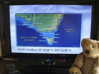
We always knew where the ship was while we were on the Queen Mary 2. The ship's GPS navigation system played information on a special TV channel in all of the cabins. You could always see where we were on a map of Australia and get the position, sea conditions, weather, distance to the next port, distance from the last port, local time, and the program of events for the day. When this photo was taken we had left Adelaide and were going through Backstairs Passage between Kangaroo Island (KI) and the mainland. We saw three of the lighthouses that we visited on our road trips, one near Adelaide and two on the coast of KI. It was still afternoon when we passed KI, so we didn't see those two shining, but we did see the Marino Rocks one flashing on our way into Adelaide before dawn that morning. It's great knowing just where the ship is, because this part of the southern coast of Australia is called the "shipwreck coast" and lots of ships came to grief here in the days before modern navigation aids.
Labels: boats, cruising
# posted by Bart Bear @ 2:46 pm

 We always knew where the ship was while we were on the Queen Mary 2. The ship's GPS navigation system played information on a special TV channel in all of the cabins. You could always see where we were on a map of Australia and get the position, sea conditions, weather, distance to the next port, distance from the last port, local time, and the program of events for the day. When this photo was taken we had left Adelaide and were going through Backstairs Passage between Kangaroo Island (KI) and the mainland. We saw three of the lighthouses that we visited on our road trips, one near Adelaide and two on the coast of KI. It was still afternoon when we passed KI, so we didn't see those two shining, but we did see the Marino Rocks one flashing on our way into Adelaide before dawn that morning. It's great knowing just where the ship is, because this part of the southern coast of Australia is called the "shipwreck coast" and lots of ships came to grief here in the days before modern navigation aids.