Tuesday, August 21, 2018
Nu'uanu Pali

Nu'uanu Pali is one of the most important historical sites in Hawai'i. Pali is the Hawaiian word for cliff, and the cliffs here rise around 305 metres (1000 ft) above sea level. The lookout is on the site where the army of King Kamehameha won the battle which made him sovereign of all the islands of Hawai'i in May 1795. Hundreds of soldiers in the opposing army were forced over the cliff. The painting on the plaque puts the final battle just where the photo of the sharp peak was taken. It is probably quite accurate as this is the flattest area between steep ridges. The lookout is about 10 minutes drive out of Honolulu (except at peak hours) along the Pali highway. This road goes on through tunnels to the Windward (east )side towns. You get great views from the lookout; here are just two. The first is looking along the peninsula toward Kaneohe Marine Airbase (you can just see it on the original image, but not quite on this smaller one). The second is looking over Kaneohe town and bay. The island is Coconut Island. It is a marine science station of the University of Hawaii, but some of the Oldies might recognize it from the opening scenes of "Gilligan's Island". It was cloudy and drizzling rain when we were at the Pali, so it is another of the places in Oahu that this small bear is not finished with.
Labels: Hawaii, history
Saturday, August 18, 2018
Hawaiian Royalty

I like statues. They are usually of people who were important to the place they are erected in. Here are 3 of the ones I found in Oahu. The first one is of King Kamehameha 1, the first ruler of the united Hawaiian islands. He was born sometime in the mid-1700s and eventually became ruler over most of the Big Island (Hawai'i). European traders formed an alliance with him and taught him how to use guns and by 1810 he had conquered all of the islands. His reign was mostly good for the people and his laws were fair and just. He died in 1819 and, following custom, his body was hidden and has never been found. His family ruled Hawaii until Kamehameha V died in 1874. The second statue is of King David Kalakaua, the last king of Hawaii. He reigned from 1874 to 1891. He was known as the Merry Monarch because of his parties and musical ability; among other things, he repealed the ban that missionaries had imposed on the hula . His extravagant lifestyle (and the policies of his sister Liliuokalani, who succeeded him) plus his plans for a Polynesian Federation were main causes of the USA takeover of Hawaii. The last statue is of Duke Paoa Kahanamoku. He was not royal, Duke was his name, but in the world of surfing he is the undoubted king. We won 5 Olympic swimming medals and was an actor and policeman. He is remembered for bringing surfing to the world. His statue is on the shore of Waikiki beach, near where tourists are taught to surf. There is another statue of him at Freshwater Beach in Sydney, where he
gave an exhibition in 1914 that is considered to be the event that triggered
the birth of Australian surfing.
Labels: Hawaii, history
Friday, July 27, 2018
Hawaii Five 0? No
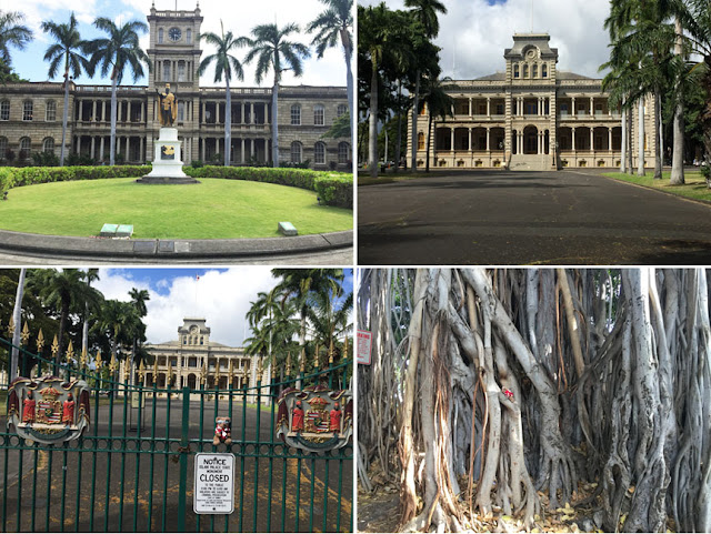
If you watch the TV program "Hawaii Five O" you will recognize these two buildings. Actually, they have nothing to do with Honolulu Police, apart from providing film locations. They are historic buildings from the time of the last Hawaiian royal family and the takeover of the islands by the USA. The first building is the Ali'iolani Hale. It was originally built in the early 1870s by King Kamehameha V. He intended it to be the royal palace, but changed the plan to be the central offices of the Hawaiian government. Today it is the Hawaiian Supreme Court building. The statue in front of the building? More about that later. Across the road is the 'Iolani Palace, which was the royal residence of the rulers of Hawaii from 1882 to 1893. It was built on the site of an earlier palace, which dated back to 1845, by the last king of Hawaii, David Kalakaua. The last monarch, his sister Queen Liliuokalani, spent a year under house arrest here after a coup ended Hawaiian royal government. Both buildings are designated as National Historic Landmarks. The palace is open Tuesday to Saturday, so naturally the Oldies took me there on a Monday and I couldn't see the inside. However, there are some spectacular banyan trees in the grounds, just right for a small bear to climb (my Aloha shirt made it easy for the Oldies to keep an eye on me), so the visit was not wasted.
Labels: buildings, climbing, Hawaii, history
Thursday, June 22, 2017
Sinister Sarah Island

Our Macquarie Harbour cruise included a visit to Sarah Island. This was the site of one of the worst penal settlements in Australia. It only operated from 1822 to 1833 and was intended to hold the worst convicts and those that had escaped from other convict settlements. Although any convict escapee would have to first cross the cold water of the harbour and then battle through the dense rain forest and its snakes and insects (see my post below), around 20 of them did escape. Most were recaptured or died in the attempt. The most notorious one was Alexander Pearce. In September 1822 he escaped with 7 others, and survived by killing and eating the others before he was caught again. He escaped again the next year, this time with a young convict; again Pearce survived by killing and eating him. On 19 July 1824 he was hanged in Hobart for his crimes. Another group of convicts escaped in a ship they were building in the government shipyard and sailed across the Pacific to Chile. When the penal station closed, the convicts were transferred to Port Arthur (see earlier posts). Today the island is part of the heritage area. The only remains of the penal colony are ruins, some in roped-off enclosures with explanatory signs and many just slowly eroding away in the jungle.
Labels: cruising, history, Tasmania
Friday, May 12, 2017
Wagga RAAF museum

Just east of Wagga Wagga is the Forest Hill RAAF base. This is the site of the RAAF College and the recruit training school. All of the recruits for non-flying areas of the RAAF learn their trades here. The RAAF doesn't use the airfield any more, it is now the Wagga Wagga airport. At the entry to the base there is a Heritage Museum and a paddock with several preserved jet aircraft on display. The aircraft have been treated for outside display. They have the canopies blacked out, the engine intake and exhaust areas closed, and armament removed. That means that the visitor can get right up to the aircraft, with the exception of the F-111. Naturally, we had to stop here. Mum really likes aircraft that look like they going supersonic even when they are on the ground, so she enjoyed "close encounters" with the F-111 and Mirage III. Dad is more into the older classics, so he spent ages checking every little bit of the Sabre, Meteor and Canberra. This small bear likes all of them and you can find me in 3 of the photos.
Labels: aircraft, history, New South Wales
Tuesday, May 02, 2017
Kapooka Tragedy Memorial

Kapooka is an outer suburb of Wagga Wagga, New South Wales. Today it is home to Blamey Barracks, the training centre for Australian Army recruits. During World War 2 part of the Defence Force site was the Royal Australian Engineers Training Centre. On May 21, 1945, the worst accident in Australian military history happened here. 27 soldiers, most of them only 18 to 20 years old, were in a bunker being taught to prepare demolition charges. Something went horribly wrong and 26 of them were killed in an explosion. We visited the site on our last road trip and there is a simple, impressive memorial there. A rectangle of 26 trees and a series of explanatory signs surround the memorial site. Each tree has a small plaque at its base with the name, rank and age of a victim. A large rock has a memorial plaque on one side and on the other, rough, side the word UBIQUE. This is a Latin word meaning "everywhere", and is the motto of most Engineering Corps in British Commonwealth countries. Here is a larger image of the words on the plaque, I think they are sad, solemn and superb. We should never forget our history.

Labels: army, history, New South Wales
Thursday, April 27, 2017
NSW Railway Engineering History

Last week, Mum had a few days off work so we did and overnight roadtrip to check out some historic things a few hours to the west of Canberra. The top images are of the Junee Roundhouse. Junee is nearly exactly half-way on the main southern railway line between Sydney and Melbourne. The line started operations back in 1878 and Junee became an important railway depot. In 1947 this huge roundhouse was built to service and repair locomotives and rolling stock. It is one of the few completely circular roundhouses and had the largest turntable in the southern hemisphere. The rail depot closed in 1993 and the roundhouse was taken over by commercial companies who use half of it to recondition locos. The other half is a museum. It is impossible to get a photo that shows the whole roundhouse, so I have copied a section of Google Eatrh that shows it. The bottom images are of a clever bit of railway engineering near the town of Bethungra, north of Junee. Here the line has to climb a steep gradient and until the early 1940s several extra engines had to be attached to boost the trains up the slope. The solution was to build a diversion that spirals around a convenient hill. That made the climb possible for all trains. Trains going downhill still use the original line, trains going uphill use the spiral. The closest I could get was a small parking bay off the highway where I could see three lines of track - the original line closest to the road and two lines of the spiral track going up the hill. Once again, Google Earth shows it clearly although you probably need to check it out using GE to get a bigger view.
Labels: engineering, history, New South Wales, train
Monday, April 24, 2017
Historic Port Arthur

One of the "must see" places in Tasmania is the ruins of the historic Port Arthur convict settlement. Port Arthur started as a small timber cutting station in 1830, but quickly grew into penal settlement with over 1100 convicts. The convicts worked at timber getting, ship building, brick and shoe making. The first 5 photos are of the large penitentiary, which actually started out as a flour mill (note the small bear climbing on the foundation stone). The large flat area of land in front of the building was initially the harbour, but one of the physical punishments inflicted on the convicts was to make them cut trees, haul them down to the harbour and sink them with stones and earth to build gardens and lawns. Tree trunks are visible in the drains here today. Imagine the immense number of trees buried here and the hard labour imposed on the convicts. The 6th and 7th images are of the Asylum, a separate prison where the worst convicts were kept in solitary confinement and where most of them went mad. The last 2 images are of the guardhouse at the entry to the penitentiary, and the ruins of the guards' barracks. The barracks were a small castle with turrets; not much remains today. Port Arthur closed as a penal settlement in 1877. On April 28, 1996, Port Arthur was the site of one of the worst acts in Australian history when a gunman, Martin Bryant, killed 35 tourists and injured 23 others before being captured. This was one instrumental in leading to Australia's strict gun laws. Mum was visiting Port Arthur just the day before. More photos of the site are coming. A good summary of the history of Port Arthur is on the website
http://portarthur.org.au.
Labels: history, Tasmania
Wednesday, March 01, 2017
The Nut

One of the long drives we did in Tasmania was to the Nut. This is the remnant of a huge volcanic plug near the town of Stanley in far north-west Tassie. The Nut has been used as background for several films. You can walk to the top, or take the chairlift. The Oldies didn't do either; they just stopped at the cafe at the end of the road for coffee and photos. I found a seat on a rail and watched the seabirds. Back in the 1820s, Stanley was the headquarters of the Van Diemen's Land company (VDLC), set up by a group of London merchants to farm the new colony, using convict labour for some jobs. You can see the ruins of one of the guard barracks near to the entry of Highfield House. This house was the residence of the company manager and it, along with a lot of the old farm buildings, has been restored and is open to visitors. The road from the Nut to Highfield has lots of great spots to get great photos of the Nut. Personally, I was really happy to see that the local cows have such a great view. On a sad note, it was the bounty that the VDLC placed on the head of the Tasmanian Tiger that was largely responsible for the tiger's extinction.
Labels: buildings, history, Tasmania
Friday, December 09, 2016
Once Was POW Camp

These pictures are of the site of Australia's Number 12 Prisoner of War camp at Cowra, New South Wales. We visited the site last weekend. During World War Two the camp held mainly Italian and Japanese POWs. The Japanese were in separate compounds for officers and other ranks. On the 5th of August 1944, 1100 Japanese prisoners attempted to escape. 359 of them succeeded in breaking out and were recaptured over the next 10 days. This was the largest prison escape of the war. 4 Australian soldiers and 231 Japanese prisoners were killed and 108 Japanese wounded. Most of the escapees intended to make their way to the coast and try to get boats; they obviously had no idea of the size of Australia. The camp was operational until the last prisoners were repatriated in 1947. Many of the Italians chose to remain in Australia. Today, all that remains at the camp site are some concrete foundations of the hospitals and mess huts. The other buildings were made only of wood and have long since disappeared. There are several memorials on the site and a replica of one of the guard towers. The site is on the Australian Register of Significant Heritage Sites. Nearby are the Japanese war cemetery and a beautiful memorial garden; you can find pictures of the garden in some of my older posts.
Labels: history, New South Wales
Monday, November 21, 2016
Historic Mayfield Mews

A fortnight ago, on one of our sunny Sunday drives, we found a piece of Australian history in a most unlikely place. This house in Bowning, a small town north of Canberra, may not look like much but it has links to two of Australia's best poets and to the Melbourne Cup. The house is Mayfield House. It belonged to the aunt of poet Henry Lawson and he lived here occasionally between 1899 and 1913. Another poet, Banjo Patterson, was sometimes a guest. Google these guys and you will find out about a "feud" between the two poets. It seems like a put-up job to this small bear as they wrote a lot of stuff in the same house and sent it to Sydney on the same train from Bowning railway station. Trains don't stop at the station anymore. Most of the tracks have been pulled up and people live in part of it. The old Coach House and stables are now Mayfield Mews, a garden centre and cafe. There is some interesting local art for sale as well and some of it makes a great climbing frame for small bears; can you see me? Back in 1861, the racehorse Archer was stabled here on his way to Melbourne where he won the first Melbourne Cup (actually, he won again the next year as well). I love our weekend drives, we always find out something new.
Labels: climbing, history, New South Wales
Friday, August 26, 2016
Country Cathedral

I am not one of those small bears who is overly impressed with churches and cathedrals but this one, St Patrick's, in Boorowa is a beaut. It is actually the second church of the same name in Boorowa. The original opened in 1855 and was demolished 130 years later. You wouldn't expect to find an impressive cathedral in a small New South Wales country town, but back in the 1870s the strong Irish community in Boorowa decided to build a splendid one that would also commemorate Daniel O'Connell, the "liberator of Ireland". The interior is really impressive, with Italian marble altars and statues. Most of the windows are stained-glass art commemorating the founding families of the town (there are a couple of plain windows left for late starters). The window above the main entrance shows the Irish connection. The 3 large sections show St Patrick, St Bridget and St Columba. The 3 small circular panels show the Irish harp, Daniel O'Connell and the badge of St Patrick. Our weekend explorations of country towns and places near Canberra are finding some wonderful surprises.
Labels: buildings, history, New South Wales
Friday, August 19, 2016
Memorial Clock
An hour and a half drive from Canberra is the small town of Boorowa. We have driven through there many times but never noticed the significant difference in the War Memorial clock tower. Dad read about it in one of our books, so we drove up two weekends ago to take a closer look. Look at the clock faces. They do not have numbers on them, they have the name ANZAC. The memorial was designed by a World War 1 veteran and built in1933 in memory of the local soldiers who served in the war. Plaques honouring them and those who served in later conflicts are attached to the sides of the building. I haven't been able to find records of other clocks with ANZAC instead of numbers, so if you are passing through Boorowa stop and take a look at this (possibly) unique monument.
Labels: history, New South Wales
Wednesday, June 22, 2016
A Real Manor House

June 11 to 13 was a 3-day weekend, celebrating the Queen's birthday. The weather was great, so Mum looked for somewhere new we could drive to. She found that Sunday was an Open Day at Iandra Castle, just over 2 hours drive away. Although Iandra is commonly called a castle it is not really one. It is more like a manor house with castle-type bits added. It is 26 km north of Young in central New South Wales. Originally it was the homestead of George Young's Mt Oriel Station. Built of reinforced concrete around 1909, the "castle" has 57 rooms. We spent a couple of hours there and didn't see every room. There is a chapel somewhere, but I couldn't find it because there were hordes of visitors and time ran out on us. There is also a separate building with stables, a blacksmith's shop, storage for buggies and big bullock drays, and living quarters for some staff upstairs. And of course there are acres of gardens and lawns. I couldn't identify all of the fruit growing in the orchard; the Oldies wouldn't let me pick any for taste testing. The whole estate is on the NSW State Heritage Register. Definitely worth visiting if you are in the area on one of the open days.
Labels: castle, history, New South Wales


 I am not one of those small bears who is overly impressed with churches and cathedrals but this one, St Patrick's, in Boorowa is a beaut. It is actually the second church of the same name in Boorowa. The original opened in 1855 and was demolished 130 years later. You wouldn't expect to find an impressive cathedral in a small New South Wales country town, but back in the 1870s the strong Irish community in Boorowa decided to build a splendid one that would also commemorate Daniel O'Connell, the "liberator of Ireland". The interior is really impressive, with Italian marble altars and statues. Most of the windows are stained-glass art commemorating the founding families of the town (there are a couple of plain windows left for late starters). The window above the main entrance shows the Irish connection. The 3 large sections show St Patrick, St Bridget and St Columba. The 3 small circular panels show the Irish harp, Daniel O'Connell and the badge of St Patrick. Our weekend explorations of country towns and places near Canberra are finding some wonderful surprises.

